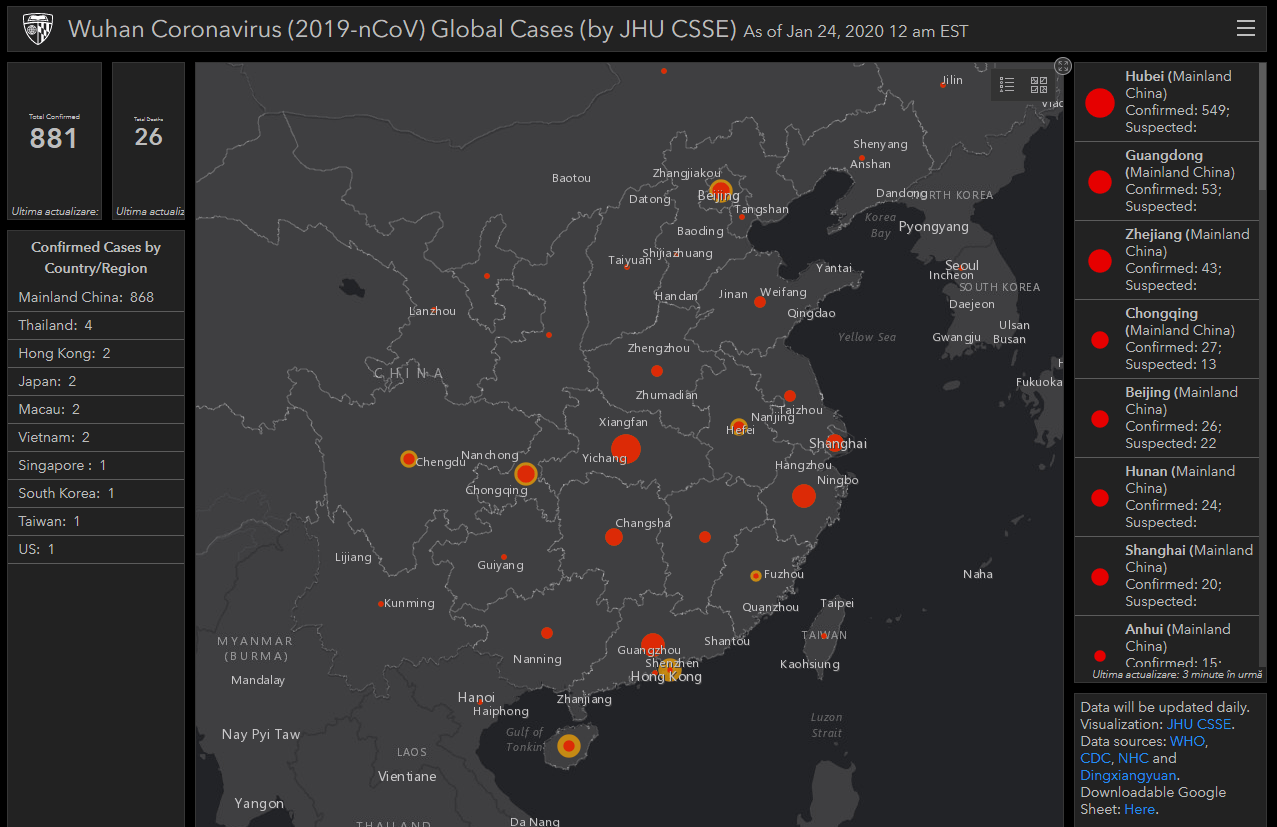
The dashboard was developed by a team at the Johns Hopkins Center for Systems Science and Engineering (CSSE) and is regularly updated — an excellent way to keep track of recent developments in the outbreak.
Since it emerged little over a month ago, the coronavirus has already made headlines all around the world — and has spread throughout the world, too. In addition to the over 800 people infected in China, patients have been reported in several Asian countries, as well as the US.
The virus seems to have jumped from bats to snakes, and then from snakes to humans, in the animal markets in Wuhan, China.
It can cause mild, flu-like symptoms, or more severe pneumonia-like symptoms, and can be life-threatening, especially in elderly patients or those who suffer from other underlying conditions.
This is already reminiscent of the 2003 SARS outbreak that killed hundreds of people, also originating in China. There are concerns that since Chinese New Year is just around the corner, millions of people will travel to and from their families, potentially helping the virus spread even more.
To help keep up with the outbreak, Lauren Gardner, a civil engineering professor and CSSE, built a simple, dynamic map (see above, below is a static image) with the disease spread and statistics.
“We built this dashboard because we think it is important for the public to have an understanding of the outbreak situation as it unfolds with transparent data sources,” Gardner said. “For the research community, this data will become more valuable as we continue to collect it over time.”
The data comes from the World Health Organization, the Centers for Disease Control and Prevention, the National Health Commission of the People’s Republic of China, and Dingxiangyuan, a social networking site for health care professionals that provides real-time information on cases.
In addition, the website offers downloadable Google Sheet data, containing information on confirmed and suspected cases in China, as well as Japan, Thailand, South Korea, Vietnam, Singapore, Colombia, Brazil, Australia, Mexico, and the United States. One case has been confirmed in Washington state. The project does not yet make any geographical predictions, but that is a feature that could be implemented.
Earlier today, the World Health Organization declined to categorize the coronavirus sweeping across China as a global health emergency. The main reason behind that is that there is no evidence of human-to-human infection outside of China.
That is what researchers are currently trying to figure out: whether or not the virus can spread from human to human, and how contagious it is.
The fact that the virus has jumped from cold-blooded animals to humans is already concerning, but this doesn’t mean that it can also spread from human to human.
If you are suffering from conditions that fit the description and believe that you may have been exposed to the virus, consult with your doctor as soon as possible.